![]()
![]()
![]()

Trip 173 - August 12-13, 2019 (Monday-Tuesday)
Horsefly Lake Road Visit
Near Horsefly BC
Location: South-Central British Columbia, near the settlement of Horsefly, which itself is located about 50 kilometers East of BC Highway 97 near 150 Mile House / Williams Lake.
Liked: Mostly very good road conditions, fine lake views from recreation sites, fish in the grass statue.
Of Note: About 40% of the road is made of gravel, with some potholes. Dusty conditions may also occur on the gravel stretch of the road.
Cariboo Chilcotin Coast BC Backroad Mapbook (4th edition) Road Location Coordinates: Page 29 (Williams Lake) D5-E4-F3-G3, then Page 30 (Horsefly) A3-B2-C2-D1-E1, then Page 44 (Likely) E7.
Horsefly Lake Road is not a terribly scenic drive, and mostly passes by forests and ranches. However, it is deserving of a trip report for two main reasons: 1) it leads to four fine recreation sites, and 2) it provides initial directions for the three trip reports which will follow: Horsefly Mountain Trail Hike, Horsefly Lake Provincial Park Visit, and Viewland Mountain Trail Hike.
Horsefly Lake Road, despite some potholes, is suitable for just about any vehicle. Except that access to Kleene Lake Recreation Site, and, especially, Quesnel Lake Public Landing Recreation Site (QLPL RS) is better left for high clearance vehicles. There is also lots of sand at the QLPL RS, as well as very steep last 100 meters (getting OUT would be most difficult), so make sure your vehicle is capable of handling the conditions.
Despite the fact that it was almost the middle of August, out of all the camping spots in all four recreation site, only one spot was occupied (at QLPL RS), albeit by a large party. Horsefly Lake Provincial Park also had many available spots.
We will start on BC Highway 97, then turn onto Likely Road, which will be followed by Horsefly Road, then Horsefly Lake Road itself, which smoothly turns into Haggens Point Road (Z Road) at a point which is hard to determine. Please, note, that there are several ways of getting onto Horsefly Lake Road, other than turning off from Highway 97 as described below, but those other ways are beyond the scope of this trip report.
Zero your odometer after turning onto Likely Road from Highway 97 (photo #2), and these are the distances to various attractions from that turnoff. RS = Recreation Site. All recreation sites have pit toilets, and no services. The maximum stay is 14 consecutive days. There is also a boat launch at each recreation site, though some boat launches are better than others, as far as available space and steepness of the terrain.
4.5 Km – Likely Rd (Left) / Horsefly Rd (stay Right)
48.7 km – Welcome to Horsefly sign
51.2 km – Horsefly Rd @ Horsefly Lake Rd - turn Right past Clarke’s general store
51.7 km – Horsefly River spawning channel – fish statue in the grass
52.5 km – Horsefly Lake Rd (stay Left) / Black Creek Rd (Right)
52.8 km – gravel road starts
59.0 km – Lemon Lake Road on Right (to Horsefly Mountain Trail)
64.2 km – Horsefly Lake Provincial Park entrance on Right
74.5 km – Viewland Forest Service Road on Right (to Viewland Mountain Trail)
83.3 km – Jacques Lake RS (on Right)
86.9 km – Keno Lake RS (on Left)
88.9 km – Kleene Lake RS turnoff (on Left) – 3.2 km to RS
89.5 km – Quesnel Lake Public Landing RS turnoff (on Left)
91.8 km – arrive Quesnel Lake Public Landing RS
1. We are Northbound on BC Highway 97 in 150 Mile House, with Williams Lake being ten minutes further to the North.

BC Highway 97 North in 150 Mile House British Columbia Canada
2. A few hundred meters past the sign seen in the photo above, make a right turn onto Likely Road. Zero your odometer at the turn.

BC Highway 97 North at Likely Road turnoff in 150 Mile House
3. 4.5 kilometers after Highway 97, follow the sign and stay to the right (straight) - that would be the beginning of Horsefly Road. Turning left onto Likely Road would eventually lead to Quesnel Forks Historic Site, Bullion Pit Mine Canyon Trail, Browntop Mountain Trail, and Cameron Ridge Trail.

Likely Road by Horsefly Road near 150 Mile House BC Canada
4. Now on Horsefly Road. It has very little traffic, with ranches and forests along the way.

Horsefly Road British Columbia
5. Entering the settlement of Horsefly, 48.7 km past Highway 97 turnoff.

Entering Horsefly BC
6-8. At the 51.2 km mark, immediately after Clarke's General Store seen on the right side in photo #6, turn right from Horsefly Road onto Horsefly Lake Road, which begins at the bridge shown in photo #8.

Clarke's General Store Horsefly British Columbia

Horsefly Road at Horsefly Lake Road in Horsefly BC

Bridge Across Horsefly River in Horsefly British Columbia
9. At 51.7 km, just 500 meters from the start of Horsefly Lake Road, there is Horsefly River Spawning Channel, with a board providing information about this attraction.

Horsefly River Spawning Channel Parking Area and Information Board
10. Just to the right of where we took the photo above, there is this neat fish in the grass statue.

Fish Statue Horsefly BC
11. Less than a kilometer later, at the 52.5 km mark, Horsefly Lake Road is to the left, while Black Creek Road is to the right.

Horsefly Lake Road at Black Creek Road near Horsefly BC Canada
12. Three hundred meters past that split, asphalt ends, and gravel (along with occasional potholes) begins.

Horsefly Lake Road end of asphalt
13. At the 59.0 km mark, Lemon Lake Road begins on the right - it eventually leads to Horsefly Mountain Trail, covered in the next trip report.

Horsefly Lake Road at Lemon Lake Road turnoff
14. Horsefly Lake Road past Lemon Lake Road turnoff.

Horsefly Lake Road British Columbia Canada
15. At the 64.2 km mark, Horsefly Lake Provincial Park entrance is on the right side.

Horsefly Lake Road at Horsefly Lake Provincial Park entrance
16. Viewland Forest Service Road turnoff arrives at the 74.5 km mark, and leads to Viewland Mountain Trail very shortly.

Horsefly Lake Road at Viewland FSR turnoff
17. Continuing on what is now Haggens Point Road / Z Road (though it's unclear at what point Horsefly Lake Road is done). At the 83.3 km mark is the entrance to Jacques Lake Recreation Site.

Haggens Point Road (Z Road) at Jacques Lake Recreation Site turnoff
18. Here is a view after turning from the main road.

Road to Jacques Lake Recreation Site near Horsefly British Columbia
19. Jacques Lake.

Jacques Lake near Horsefly BC Canada
20. There are six camping spots at Jacques Lake Recreation Site.

Jacques Lake Recreation Site
21. Continuing on Horsefly Lake Road (Haggens Point Road by this, ahem, point), at the 86.9 km mark Keno Lake Recreation Site is right by the road. So, all the traffic noise (and associated dust) would make it for a less than serene stay. Unless you want to launch a boat and paddle away from it all. There are two camping spots here, well separated from each other.

Keno Lake Recreation Site by Haggens Point Road (Z Road)
22. A short path to the boat launch.

Path to boat launch at Keno Lake Recreation Site
23. Keno Lake.

Keno Lake near Horsefly British Columbia
24. Driving further, at the 88.9 km mark, there is a split. Klinne Lake Recreation Site is 3 kilometers to the left, and Quesnel Lake Public Landing Recreation Site is 3 km to the right.

Haggens Point Road (Z Road) near Klinne Lake Recreation Site
25. We are visiting Klinne Lake first, so here is the road. There is a split closer to the lake - make another left turn.

Road to Klinne Lake Recreation Site British Columbia Canada
26. And here is Klinne Lake Recreation Site. There are two camping spots, in close proximity. The site is rather small.

Klinne Lake Recreation Site near Horsefly BC Canada
27. Klinne Lake.

Klinne Lake near Horsefly BC
28. We are back on Haggens Point Road. At the 89.5 km mark, Quesnel Lake Public Landing Recreation Site turnoff is on the left. Continuing straight would lead to Elysia Resort.

Haggens Point Road (Z Road) near Quesnel Lake Public Landing Recreation
Site
29. We have turned left, and it's another 2.3 km to the recreation site, on a pretty rough road. A high clearance vehicle may be required.

Road to Quesnel Lake Public Landing Recreation Site
30. Arriving at Quesnel Lake Public Landing Recreation Site. Coordinates: N 52⁰31.120' W 121⁰05.935'. Elevation: 720 meters. It's by far the most picturesque of the four recreation site on Haggens Point Road (Z Road) / Horsefly Lake Road.

Quesnel Lake Public Landing Recreation Site
31. There is actually a sandy beach there, albeit with lots of small stones. Be careful with your vehicle, lest it gets stuck in the sand. Also, the road exiting the site is VERY steep, so a 4x4 might be in order, if the road is wet/muddy.

Beach on Quesnel Lake Public Landing Recreation Site near Horsefly
British Columbia
32. The recreation site continues for several hundred meters, and has four camping spots.

Quesnel Lake British Columbia
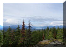
33. Quesnel Lake and the surrounding mountains look very good from this place.

View of Quesnel Lake from Recreation Site
34. Now with some zoom.

Quesnel Lake
Horsefly Lake Road / Haggens Point Road (Z Road) is not an attraction by itself, but it leads to several hikes, one very fine provincial park, and four good recreation site. If you are interested in any of the above, this is the right road to take.


|
 |
Other Trips in Horsefly BC Area:
|
Horsefly Lake Prov
Park
|
|
Other Trips:


![]()


![]()
![]()
![]()
ihikebc.com Trip 173 - Horsefly Lake Road Visit (Near Horsefly BC)