![]()
![]()
![]()

Trip 128 - July 29, 2017 (Saturday)
Summit Peak Trail Hike
Stone Mountain Provincial Park (North of Fort Nelson)
Location: Northeastern British Columbia, in Stone Mountain
Provincial Park, by Highway 97, approximately 140 kilometers North of
Fort Nelson.
Liked: Easy access to trailhead off Highway 97. Panoramic mountain views. Ability to walk on a dry river bed. Virtually no bugs.
Of note: The trail is popular. The second half of the trail is substantially steep, and the path often consists of small loose sharp stones. A creek crossing is required shortly after the start of the trail. Hiking poles and boots are highly recommended.
Northern BC Backroad Mapbook (3rd edition) Approximate Trailhead Location (not marked on the map):
Page 80 (Steamboat) C5.Related Website:
Stone Mountain Provincial Park - BC Parks official site.Other Trips in Fort Nelson Area: Dunedin Trail, Fort Nelson BC Visit, Teetering Rock Trail, Summit Ridge Trail, Stone's Sheep Trail.
Summit Peak Trail, just like Summit Ridge Trail that we hiked yesterday, is located in Northeastern British Columbia, in Stone Mountain Provincial Park, about 1.5 hr drive North from Fort Nelson. Unlike yesterday's trail, Summit Peak is not as easy, and the second half of the trail would make those who don't have hiking boots and poles rather unhappy, especially on the way down. Summit Peak Trail has two viewpoints, and today we hiked only to the first viewpoint, due to the threatening clouds in the area. We have seen no people on the way up, but met about 10 hikers on the way down. This was by far the most people we have met on any of the Northern BC trails, except for Teapot Mountain Trail near Prince George.
1. We are Northbound on Highway 97, about 136 kilometers North of Fort Nelson, and are entering Stone Mountain Provincial Park.

BC Highway 97 at Stone Mountain Provincial Park entrance
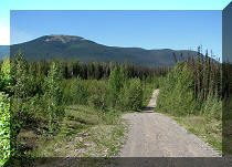
2. Just over three kilometers later (and 1.2 km North of the Summit Ridge parking area), there is a parking area for Summit Peak Trail, right across from the Summit Lake Campground. A pit toilet is located by the trailhead. Coordinates for the parking area: N 58⁰39.127' W 124⁰39.068'. Elevation: 1,279 meters.

Parking area for Summit Peak trail in Northeastern British Columbia
Canada
3. An information board describes the trail and shows tough stretches. As you can see, there is a lot of red there.

Summit Peak Trail Information Board - Stone Mountain Provincial Park BC
Canada
4. The hike begins. The mountain ahead is NOT our destination. Summit Peak is to the right, and we will see it shortly.

Summit Peak Trail Northeastern British Columbia Canada
5. In about a minute, don't miss a right turn, which would lead across a small creek (there was almost no water flowing at the time of the hike), and into a pleasant forest. You can see a not-very-obvious stone barrier ahead, which we missed, and only discovered on our way back.

Summit Peak Trail British Columbia Canada
6. Missing the turn, we still got to go through a pleasant forest on the left side of the nearly dry creek.

Alaska Highway Trail - Summit Peak Trail in Stone Mountain Provincial
Park
7. But, the forest on the left side, unlike on the right side, ends very shortly. We were then forced to hike up the dry creek bed, which was fine by us.

Alaska Highway Hike
8. You probably won't see this neat view if you take the regular path on the right side of the creek. That's the same mountain as seen in photos #1 and #4.

Stone Mountain Provincial Park Hiking
9. Thanks to the GPS, which showed the actual trail location, we realized that Summit Peak was to the right, and turned that way.

Hike in British Columbia
10. Looking to the right, this is where we need to go.

Hike Stone Mountain Provincial Park British Columbia Canada
11. The climb begins.

Canada Hiking
12. The good thing about this trail is that the higher you climb, the better and better is the view behind you.

Stone Mountain Provincial Park Trail - Stone Peak Trail
13. Repeat the exercise: a) climb higher...

Hike North of Fort Nelson in Stone Mountain Provincial Park
14...b) turn around and let your eyes enjoy the fruit of your legs' labour.

View from Summit Peak trail BC Canada
15. Looking a bit to the left, that's Summit Lake Campground.

Alaska Highway Hike - Summit Peak Trail North of Fort Nelson BC Canada
16. Zooming in 12x.

Summit Lake Campground in Stone Mountain Provincial Park North of Fort
Nelson BC Canada
17. In the meanwhile, we have reached a point where one could see both the first viewpoint (closer to the center of the photo), and the second viewpoint (trail end) on the far left.

Stone Mountain Provincial Park Hike
18. The legs are working, the eyes are enjoying.
View from Summit Peak Trail Province of BC Canada
19. The final climb to the first viewpoint. Not as steep as Murray Range Trail, but a good workout, nonetheless.

Summit Peak Trail in Stone Mountain Provincial Park - Alaska Highway
Hike
20. The view...

View from the first viewpoint of Summit Peak trail Northeastern British
Columbia Canada
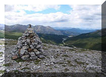
21. And now we are at the first viewpoint. Coordinates: N 58⁰40.276' W 124⁰38.972'. Elevation: 1,976 meters (697 meters elevation gain from the trailhead). Looking towards the continuation of the trail and the second viewpoint.

British Columbia Trail - Summit Peak Hike in Northern BC
22. Now looking back at what we have just climbed.

Stone Mountain Provincial Park
23. Looking to the right.

Hike in Stone Mountain Provincial Park British Columbia Canada
Here is our video of the view from the first viewpoint:
More ihikebc videos are on our YouTube Channel.
24. Our stats to the first viewpoint. 2 hours 20 minutes total time. Fairly slow moving average at 2.4 km/h.

GPSMAP 64s
25-27. On the drive back, met a caribou crossing the highway.

Caribou

Caribou in British Columbia

Caribou in Stone Mountain Provincial Park Area
Summit Peak Trail leads to great views, and is definitely recommended.


|
 |
Other Trips off Alaska Highway / BC Hwy 97:
|
|
|
|
|
|
|
Other Trips:


![]()


![]()
![]()
![]()
ihikebc.com Trip 128 - Summit Peak Trail Hike (Stone Mountain Provincial Park)