![]()
![]()
![]()

Trip 142 - August 15, 2018 (Wednesday)
Harvey Mountain Trail Hike
Babine Mountains Provincial Park
Near Smithers, BC
Location: In Babine Mountains Provincial Park, near the town of Smithers,
which is approximately 370 kilometers
West of Prince George via Highway 16.
Liked: Good trailhead access road, mountain views, steady elevation gain, shade in the forest, vast alpine area, no bugs, the ability to bike on the way back.
Of Note: Remote wilderness area, limited parking by the trailhead, hiking poles and boots are recommended.
Northern BC Backroad Mapbook (3rd edition) Trail Coordinates: Page 36 (Smithers) C5-C4.
Related Websites: Babine Mountains Provincial Park, Driftwood Canyon Provincial Park - BC Parks official websites.
Other Trips in Babine Mountains Provincial Park: Silver King Basin Trail Hike, Hyland Pass Trail Hike.
Follow @ihikebc Tweet
We have read and heard many times about how beautiful Babine Mountains Provincial Park is, and were eager to see this part of British Columbia. There are about seven major trails in the park, and Harvey Mountain is one of the several trails where biking is allowed. So, we pushed our bike all the way to the sub-alpine, as the trail had hardly any flat stretches, and then hiked to the top of Harvey Mountain and beyond. On the way back, it was one quick ride - about an hour and a half saved, for sure. As far as the beauty of this area, we have certainly seen more beautiful places in BC, but, that said, there were some very good views, which made for a fine hike. Besides, other trails in this provincial park may be even more impressive.
1. To get to Babine Mountains Provincial Park, drive as follows: from Highway 16 just East of Smithers, turn onto Old Babine Lake Road and zero your odometer. At 4.7 km, turn left onto McCabe Road. Drive past Malkow Lookout trailhead (our previous trip report) at 6.3 km. Then, at 8.3 km, turn left onto Telkwa High Road. Two hundred meters later, at 8.5 km, turn right onto Driftwood Road, which will take you past Driftwood Canyon Provincial Park to Babine Mountains Provincial Park with its numerous trails. Curiously, while plentiful signs direct drivers to Driftwood Canyon Provincial Park, we have not seen a single sign indicating the way to Babine Mountains Provincial Park. So, here we are on McCabe Road, 8.3 km after turning onto Old Babine Lake Road from Highway 16, ready to turn left onto Telkwa High Road. Malkow Lookout trip report has photo-directions on getting to McCabe Road from BC Highway 16.
McCabe Road at Telkwa High Road near Smithers BC
Canada
2. After driving for 200 meters on Telkwa High Road, turn right onto Driftwood Road. The sign indicates 4 km to Driftwood Canyon Provincial Park.
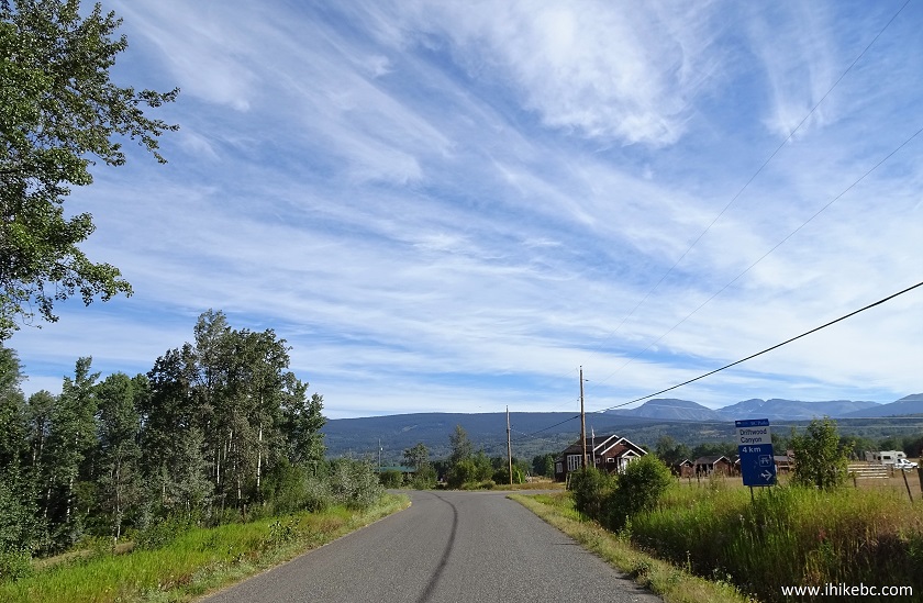
Telkwa High Road at Driftwood Road by Smithers
British Columbia
3. Now on Driftwood Road.

Driftwood Road near Smithers BC Canada
4. At 12.5 km, we are in Driftwood Canyon Provincial Park. The road continues past the camping area seen on the right side. There is a pit toilet and a garbage bin there, as well as a short trail.

Driftwood Canyon Provincial Park near Smithers
British Columbia
5. Continuing on Driftwood Road.

Driftwood Road near Smithers British Columbia Canada
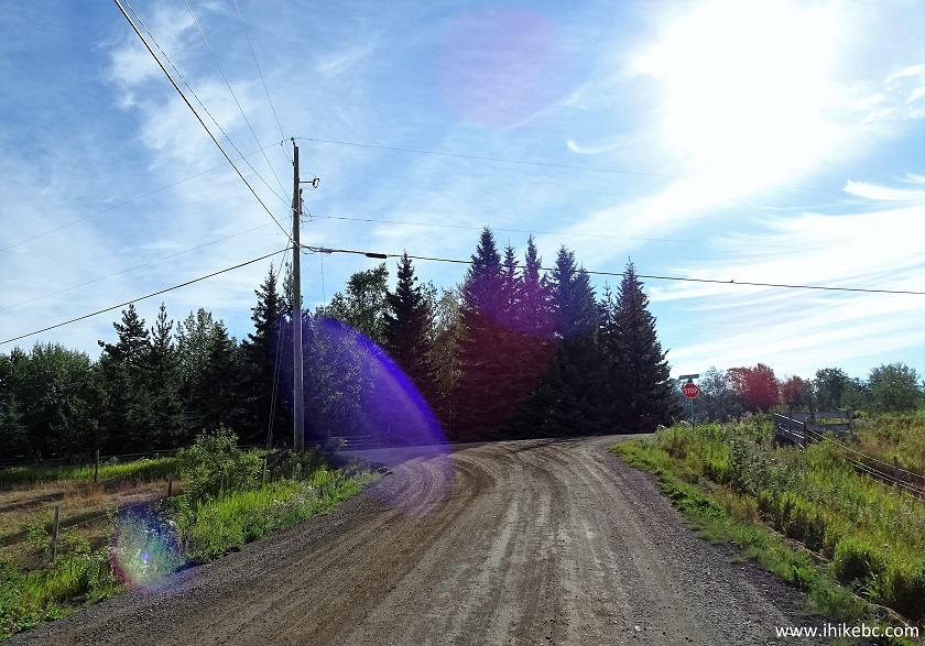
6. At the 15.2 km mark, Driftwood Road ends at the entrance to Babine Mountains Provincial Park. The sign warns of a rough road, but the road (gravel) is in good shape, with a few potholes here and there. The sign further states 1.4 km to Lyon Creek trailhead, 3.7 km to Harvey Mountain trailhead, and 4.3 km to park information (which is also the start of three other trails on this side of the park: McCabe, Silver King Basin, and Fletcher-Gardiner).

Entrance to Babine Mountains Provincial Park near
Smithers BC Canada
7. As promised, 3.7 km later is Harvey Mountain trailhead (it's by the info stand in front of the parked vehicle in the photo below). Coordinates: N 54⁰52.160' W 126⁰58.220'. Elevation: 950 meters. Note a limited parking area - good for fifteen vehicles or so. The access road is too narrow to park along it, and the main parking lot 600 meters ahead is only large enough to hold about ten more vehicles, so folks hiking three trails from the main lot may have to park at the Harvey Mountain trailhead.

Harvey Mountain Trail Parking Area Babine Mountains
Provincial Park near Smithers BC Canada
8. Let's go. Self-registration is available.

Babine Mountains Provincial Park - Harvey Mountain
Trailhead
9. The majority of the hike is in a view-deficient forest, but it has lots of shade, no bugs, and very few really steep sections. That said, biking uphill is not going to happen - way too steep for that. We biked for a total of, maybe, a minute on the way up.

Harvey Mountain Trail - Smithers Hiking - Babine
Mountains Provincial Park
10. One of the few steeper than average parts of the trail. It's steeper than it looks.

Smithers Trail - Babine Mountains Provincial Park -
Harvey Mountain Trail
11. Slightly over 4 kilometers after the start of the hike, the trail enters sub-alpine, and Harvey Mountain appears ahead.

Harvey Mountain Trail - Smithers Hike - Babine
Mountains Provincial Park - British Columbia Canada
12. It's a neat mountain, and quite easy to get to, all things considered.

Harvey Mountain - Trail in Smithers BC Canada Area in Babine
Mountains Provincial Park
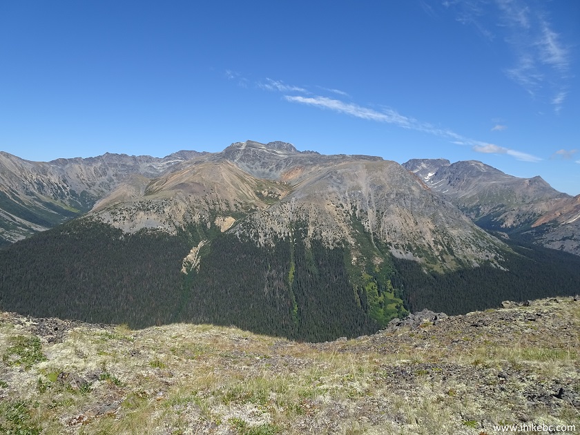
13. Looking back at Hudson Bay Mountain with a glacier. We have hiked up to this glacier a few days later via a Glacier Gulch Trail.

Hudson Bay Mountain near Smithers BC seen from Harvey
Mountain Trail
14. Zoomed view x7.

Hudson Bay Mountain Glacier seen from Harvey Mountain
near Smithers BC Canada
15. The trail end is near.

Near the end of Harvey Mountain Trail in Babine
Mountain Provincial Park - Hike in Smithers Area BC Canada
16. And here we are, at a small cairn at the end of the trail. Coordinates: N 54⁰52.802' W 126⁰56.227'. Elevation: 1,751 meters (801 meters elevation gain from the start of the trail, for an average grade of 16%). The length of the trail is exactly 5.00 km, and it took us just over 2.5 hours to get here, while pushing a bicycle most of the way, with an average moving speed of 3.2 km/h.

End of Harvey Mountain Trail - Hiking in Smithers BC Canada
Area
Here is Our Video of the Views from the Top of Harvey Mountain.
The glacier seen in the video is on top of Hudson Bay Mountain - we hiked to that glacier several days later (Glacier Gulch trip report).
More ihikebc videos are on our YouTube Channel.
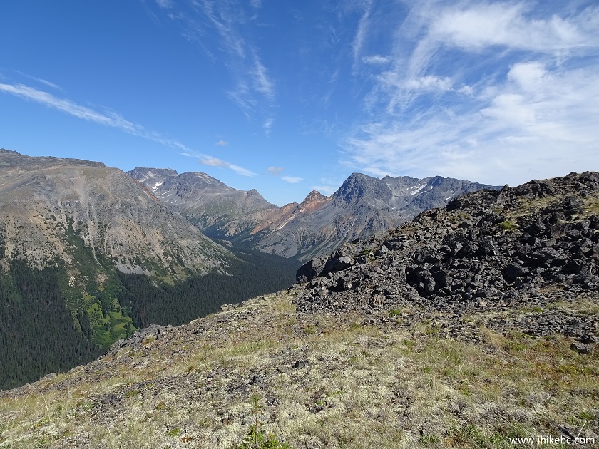
17. The views from the top are decent. However, for the best views, even if you have only ten minutes to spare, head to the left.

Harvey Mountain Alpine Area - Babine Mountains
Provincial Park - Smithers British Columbia Hiking
18. You can hike along the edge of the alpine area for several kilometers without any major elevation changes.
View from Harvey Mountain Alpine Area near Smithers
- Hike in British Columbia Canada
19. But, to see arguably the best view of the hike, all you need is ten minutes of hiking from the top of Harvey Mountain. Same left side.
Smithers Hiking - Babine Mountains Provincial Park -
Harvey Mountain Alpine Area - Trail in British Columbia
20. Zooming in. It really is quite neat to sit down and enjoy a panoramic view of the mountains in photos 17 through 19.

View from Harvey Mountain Alpine Area in Babine
Mountains Provincial Park near Smithers British Columbia Canada
21. Going further along the left side of the alpine.

Smithers Hiking - Harvey Mountain Alpine Area in
Babine Mountains Provincial Park
22. Pretty cool.
Babine Mountains Provincial Park - Harvey Mountain
Alpine Area - Canada Hiking
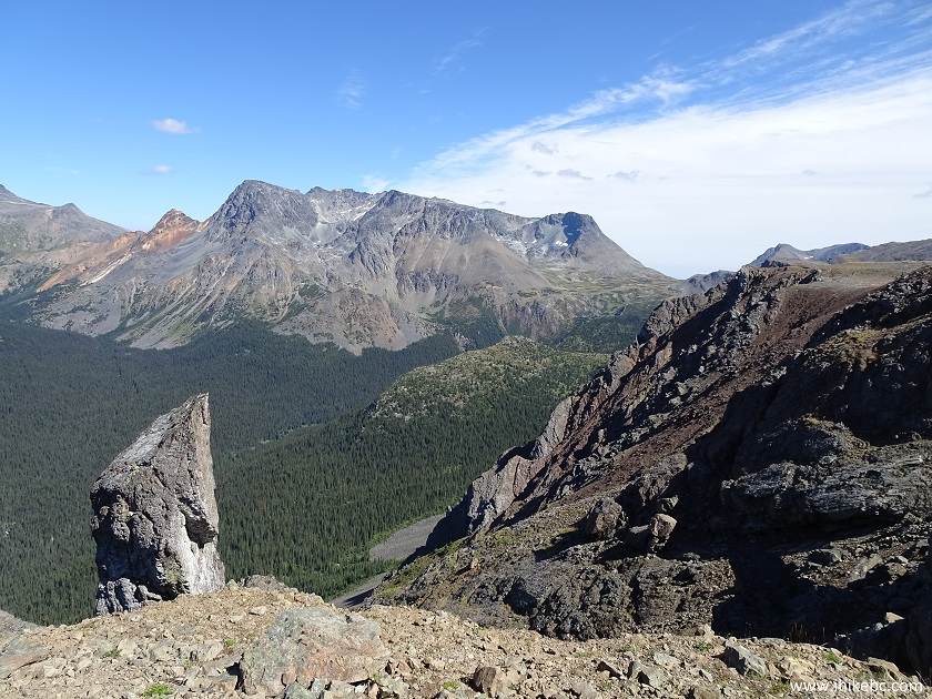
23. After about two kilometers, you would be forced to steeply descend and then climb up to reach the protrusion seen on the middle-right side of the photo below.

Smithers Hiking - Babine Mountains Provincial Park -
Harvey Mountain Alpine Area
24. We decided to head back by making a small circle in the vast alpine area, and discovered a lake below. Coordinates: N 54⁰52.505' W 126⁰55.102'. Elevation: 1,757 meters. Our GPS showed that Blix Route, connecting McCabe Trail (to the left) and Lyons Creek Trail (to the right) runs along the lake. So, it's possible to start hiking on Harvey Mountain Trail, and finish on another trail, if you have enough time to do a loop, or have a car shuttle to speed things up.

Lake in Babine Mountains Provincial Park near
Smithers BC Canada
There was not much to see in the alpine on the way back along the right side of it, as all the great views are on the left side of the Harvey Mountain alpine area. It took us less than 30 minutes to bike downhill, sitting on the brakes all the time. If biking, beware of any hikers on your way down, as there are many switchbacks and blind corners. There is also a locked gate closer to the alpine, which you will discover on your way up. Harvey Mountain Trail is definitely recommended for being a rather short and easy hike to see some very fine views.


|
 |
Other Trips in Smithers BC Area:
|
|
|
|
|
|
|
|
|
|
|
|
|
Fletcher-Gardiner Trail  |
Other Trips:


![]()


![]()
![]()
![]()
Follow @ihikebc Tweet
ihikebc.com Trip 142 - Harvey Mountain Trail Hike (near Smithers BC)