![]()
![]()
![]()

Trip 117 - September 3, 2016 (Saturday)
Stone's Sheep Trail Hike
Muncho Lake Provincial Park
Page 1 of 2
Trailhead Location: Northeastern British Columbia,
by Highway 97, approximately 245 kilometers North of
Fort Nelson.
Liked: Mountain views, glacier view, stone pillars, balancing stone, "brick" stones, meeting a pair of Stone Sheep, no bugs, gentle elevation gain.
Of note: Very rough surface for most of the trail past the first waterfall, a short but complicated climb by the first waterfall, numerous creek crossings are required (mostly after the first waterfall). Hiking poles and boots are highly recommended to the first waterfall, and are essential, if you want to proceed further.
Northern BC Backroad Mapbook (3rd edition) Trailhead Coordinates: Page 73 (Muncho Lake) E3.
Related Website: BC Parks - Muncho Lake Provincial Park.
Other Trips in Fort Nelson Area: Dunedin Trail, Fort Nelson BC Visit, Teetering Rock Trail, Summit Peak Trail, Summit Ridge Trail.
Stone's Sheep trail is so named because Stone sheep live in the area. The sheep are so named after a certain Mr. Stone. There are plenty of "stones" on this great trail: stone pillars, which provide fine visuals; a balancing stone, which looks like it might fall very soon; and also "brick" stones, which resemble ancient remains of a Roman water source. On top of that, there are tons of regular stones, right under your feet. They come in all shapes and sizes, many of them are unsteady, and some of them are very sharp too. This trail is a broken ankle waiting to happen, especially past the first waterfall.
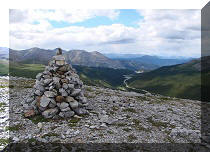
1. Stone's Sheep trailhead is located in Muncho Lake Provincial Park, almost halfway between Fort Nelson, BC and Watson Lake, Yukon. Here we are driving North on BC Highway 97, and are approaching a large parking lot by the trailhead, located 3.8 km past Strawberry Flats campground. Coordinates for the parking lot: N 58⁰58.901' W 125⁰45.913'. Elevation: 837 meters.

BC Highway 97 in Muncho Lake Provincial Park
2. An information board describes the trail and shows the map. Not quite sure what the coordinates for the viewpoint refer to, as there are so many great views out there, and we could not find the exact spot on the way back with our automotive GPS.

Information Board for Stone's Sheep Trail Northeastern BC Canada
3. The trail begins right by the parking lot. The idea is simple - cross a narrow dyke, head towards the trees, then turn right and keep walking with the trees on your left, and make left turns whenever possible. The mountains would then close in around you, and you would be in a small canyon and reach the first waterfall.

Alaska Highway Trail -
Stone's Sheep Trail British Columbia Canada
4. We have now reached the trees, turned right, and are keeping the trees to our left. There is a discernible path among the stones here and there.

Stone's Sheep Trail Muncho Lake Provincial Park BC Canada
5. There are also several cairns for guidance, but not much in terms of flagging tape or other markers.

Alaska Highway Hiking -
Cairns on Stone's Sheep Trail
6. We can now see the canyon ahead, as well as meet the creek which we would cross at least twice before the first waterfall, and dozens more times after that.

Stone's Sheep Trail British Columbia Canada - Alaska Highway Hike
7. Almost by the canyon, we see stone pillars on the right side.

Stone's Sheep Trail Province of BC Canada - Muncho Lake Provincial Park
Trail
8. Even with the sun in our eyes, these pillars were very interesting to look at.
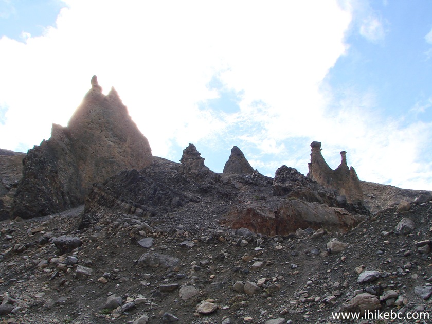
Stone Pillars by Stone's Sheep Trail Northeastern British Columbia
Canada
9. Neat.

Stone Pillars Muncho Lake Provincial Park Hiking BC Canada
10. A few more.

Stone Pillars - BC Trail
11. You could really shoot a movie about an alien planet in this place.

Stone Pillars by Stone's Sheep Trail in Muncho Lake Provincial Park
British Columbia Canada
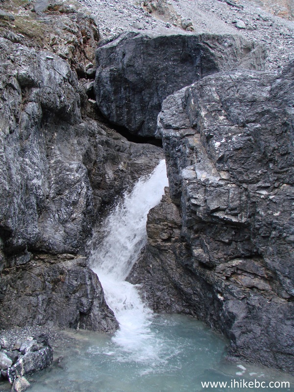
12. Soon after the stone pillars, the canyon walls closed in on us, and we approached the first waterfall, approximately 1.5 hours after starting the hike.

Canyon - Stone's Sheep Trail - Hiking in British Columbia
13. It's quite a neat view too.

Stone's Sheep Trail Muncho Lake Provincial Park
14. The waterfall is to the left, a very short but treacherous climb is on the right, and a small inukshuk is on top.

Stone's Sheep Trail First Waterfall - Canada Hiking
15. Here is the waterfall. Coordinates: N 58⁰58.714' W 125⁰41.119'. Elevation: 1,115 meters.
First Waterfall Stone's Sheep Trail Muncho Lake Provincial Park BC
Canada
16. Here is that short but treacherous climb. You definitely would not want to go any further without hiking poles and boots.

Stone's Sheep Trail Climbing Stretch by First Waterfall
17. And here is the inukshuk. We have climbed to the top and are looking back now.

Stone's Sheep Trail Inukshuk
18. Another great scene right after the first waterfall.

Stone's Sheep Trail Northeastern British Columbia Canada
19. What was a relatively benign trail before the first waterfall, turned into a semi-dangerous, albeit beautiful, obstacle course afterwards. In addition to there being hardly any flat stretches, we had to cross the creek time and again by hopping on stones.

Stone's Sheep Trail Muncho Lake Provincial Park
20. We headed towards a glacier seen ahead, while being on a lookout for Stone sheep.

Stone's Sheep Trail
21. An hour and a half after the first waterfall (3 hours after starting the hike) we reached the second waterfall, not nearly as complicated as the first one, as it's possible to walk around it. Coordinates for the second waterfall: N 58⁰59.144' W 125⁰41.119'. Elevation: 1,417 meters.

Second Waterfall Stone's Sheep Trail BC Canada
22. The glacier is getting closer.

Glacier View Stone's Sheep Trail Muncho Lake Provincial Park BC Canada
23. A good mountain view to the right.

Mountain View Stone's Sheep Trail BC Canada
24. Shortly after the second waterfall, the canyon becomes very narrow, and you may have quite an interesting time, if the water level would be high. Two more stone pillars are seen on the right side.

Stone's Sheep Trail
25. Here they are.
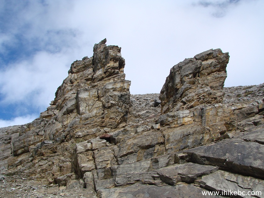
Stone Pillars Stone's Sheep Trail Northeastern British Columbia Canada
Our Stone's Sheep Trail Hike Trip Report Continues on Page 2.


|
 |
Other Trips off Alaska Highway / BC Hwy 97:
|
|
|
|
|
|
|
Other Trips:


![]()


![]()
![]()
![]()
ihikebc.com Trip 117 - Stone's Sheep Trail Hike (Muncho Lake Provincial Park) Page 1 of 2