![]()
![]()
![]()

Trip 301 - September 7 (Thursday), 9 (Saturday), 11 (Monday) and 15 (Friday), 2023.
Juan De Fuca Trail Hike
Juan De Fuca Provincial Park
Near Sooke, BC (West of Victoria)
Page 2 of 8
China Beach to Bear
Beach (km 0 to 9) and back
1) China Beach (easternmost) - about 37 km west of Sooke BC via Hwy 14, 75 km west of Victoria.
2) Sombrio Beach - about 58 km west of Sooke BC via Hwy 14.
3) Parkinson Creek - about 68 km west of Sooke BC via Hwy 14.
4) Botanical Beach (westernmost) - about 76 km west of Sooke BC via Hwy 14, in Port Renfrew.
Liked in General:
Shoreline views, tidal pools, grottos, waterfalls, three suspension bridges, several fine forest scenes, shade in the forest, no bugs.1) China Beach to Bear Beach (page 1 and this page) - Pete Wolfe Creek suspension bridge, Mystic Beach and Bear Beach shoreline views and grottos, Mystic Beach waterfall, meeting Brandt's cormorants.
2) Sombrio Beach to Chin Beach - garbage cans at Sombrio Beach parking lot, some sand at Sombrio Beach, a few tidal pools at Chin Beach, excellent grottos (with natural ceiling art) at Chin Beach, meeting a passing seal at Chin Beach.
3) Parkinson Creek to Sombrio Beach - Minute Creek suspension bridge, waterfall view from the suspension bridge, Sombrio Beach.
4) Botanical Beach to km 39 (2 km east of Parkinson Creek) - excellent tidal pools near Botanical Beach, several fine shoreline views.
Of Note in General: Camping and overnight parking fees required, high tides may cut off beach/trail access, numerous mud stretches, frequently damaged infrastructure (ladders, bridges, boardwalks), bear scat, the trail is popular, uneven ground, rocks and roots, stones of all sizes on the beach, very slippery stones in grottos and on the beach, hiking poles and boots are highly recommended. Very limited /nonexistent cell phone coverage along the trail - it might be possible to get a signal from a USA carrier (beware of roaming charges!). The entire trail is in the tsunami hazard area - head to higher ground or inland in case of an earthquake.
1) China Beach to Bear Beach (page 1 and this page) - log bridge at 6.3 km is missing railing on one side, steep ladder on approach to Bear Beach.
2) Sombrio Beach to Chin Beach - Sombrio Beach location is very popular, and the parking lot is small - may have to park along the access road during busy times. Steep unbarricaded drop-off at the first waterfall viewpoint. Very slippery stones at the top of the waterfall - extreme fall hazard, do not approach.
3) Parkinson Creek to Sombrio Beach - not much to see on this stretch of Juan De Fuca Trail.
4) Botanical Beach to km 39 (2 km east of Parkinson Creek) - overnight camping is not allowed on Botanical Beach parking lot, a whole lot of bear scat (much more than on the rest of the trail combined), tricky Yauh Creek log crossing, rogue waves hazard near Botanical Beach.
Vancouver Island, Victoria & Gulf Islands Backroad Mapbook (9th edition) Coordinates: Page 4 (Jordan River) C4-B4-A4 and Page 3 (Port Renfrew) G4-F3-E3-D3-C3.
Related Website: Juan De Fuca Provincial Park - BC Parks Official Website.
Follow @ihikebc TweetJuan De Fuca Marine Trail is a multi-day 47 km-long hike on Vancouver Island along Salish Sea between China Beach (East of Sooke BC) and Botanical Beach in Port Renfrew, BC. Both trailheads are easily accessible by vehicles via Highway 14 (West Coast Road), allowing for a one-way hike via a shuttle. Also, because there are two other vehicle-accessible locations along the trail (Sombrio Beach and Parkinson Creek), it is possible to hike Juan De Fuca Trail in series of one day hikes, which is exactly what we did. On Day 1, we hiked from China Beach to Bear Beach (km 0 to 9) and back. On Day 2, we went from Sombrio Beach to Chin Beach (not to be confused with China Beach! - km 29 to 21) and back. On Day 3, our hike was Parkinson Creek to Sombrio Beach (km 37 to 29) and back. And, on Day 4, we went from Botanical Beach to km 39 (2 km West of Parkinson Creek) and back.
Thus, we hiked the entire Juan De Fuca Trail except the part from Bear Beach to Chin Beach (km 9 to 21) and a small part between km 37 and 39. The Bear Beach to Chin Beach part was not possible to do in a day hike, and the part between km 37 and 39 was all in the forest (like the most of Juan De Fuca Trail, by the way), and we wanted to save time to explore Botanical Beach area, arguably the best part of this entire hike.
The main attractions of Juan De Fuca Trail are: three long suspension bridges, fine shoreline views at beaches and (sometimes) from the trail in the woods, wonderful tidal pools at Botanical Beach (and a few much smaller ones at other beaches), very interesting grottos at some beaches, several waterfalls, and a few interesting forest scenes. Campers would certainly enjoy spending time at the beaches (mostly made of stones, small and large), and will likely have a whole lot of other people nearby at all times aside from, perhaps, the coldest and wettest months of the year.
What surprised us is that, despite being a marine trail, the vast majority of hiking has to be done in the woods. There are no major elevation changes, so it's a fairly easy trail to hike from that perspective, but the biggest challenge comes from numerous slippery sections and rather frequently worn-out wooden infrastructure (ladders, bridges and boardwalks), presenting somewhat complicated and, sometimes, fairly dangerous conditions in many parts of the trail.
Also of note, while there are pit toilers at all the parking lots and some campsites along Juan De Fuca Trail, the garbage cans can only be found at the Sombrio Beach parking lot! There are no garbage cans at the Botanical Beach lot (there is a free public dump in Port Renfrew, open during business hours only), and none at China Beach lot either (however, there are garbage cans at China Beach campground, about 1 km east of the lot). Overnight parking and backcountry camping requires a fee. Parking around Port Renfrew is complicated. No overnight camping is allowed at the Botanical Beach lot, and there is a forest service road fairly close by (just east of Port Renfrew), but it does not have a good level spot for parking, unless you manage to find one.
Furthermore, there will likely be a whole lot of mud on this trail if you hike it at any time aside from, perhaps, late Summer and early Fall. But hiking during the drier season also means that the waterfalls along Juan De Fuca Trail (there are a few) would not be as impressive due to a much smaller volume of water.
Finally, there are no fresh water taps anywhere along the trail. Be prepared to have your water boiled or treated, especially if you plan on having a multi-day hike.
* All trail distances are based on a GPS odometer and are approximate.
31. Now at the 2.84 km mark of Juan De Fuca Trail (China Beach to Bear Beach - km 0 to 9).

Juan De Fuca Trail China Beach to Bear Beach
32. A spectacular mess across the trail at 3.14 km.

Juan De Fuca Provincial Park British Columbia Canada
33. There are brushed-in sections here and there. This one is at the 3.34 km mark. We stumbled upon a park ranger with a chainsaw clearing one such stretch.

Hike in Juan De Fuca Provincial Park
34. At 3.51 km, we are crossing Pat Philip Creek bridge.

Pat Phillip Creek Bridge - Juan De Fuca Trail
35. A view from the bridge.

Juan De Fuca Provincial Park on Vancouver Island BC
36. More boardwalk at 3.90 km of Juan De Fuca Trail.

Juan De Fuca Trail
37. And another bridge at the 4.92 km mark.

Juan De Fuca Trail bridge
38. Finally, a good view of Salish Sea at 4.97 km.

Salish Sea view from Juan De Fuca Trail in British Columbia Canada
39. Another one 800 meters later.

View from Juan De Fuca Trail
40. A log bridge at 6.3 km is missing a bit of railing on one side.

Juan De Fuca Trail log bridge
41. At 7.36 km, there is a short muddy stretch. This being the end of a dry season, mud wasn't too bad on Juan De Fuca Trail during our visit, but it can get VERY muddy at all other times of the year.

Juan De Fuca Trail muddy stretch
42. Going through the forest at 7.88 km. The vast majority of Juan De Fuca Trail is forest hiking.

Hiking through a forest in Juan De Fuca Provincial Park
43. A long steep staircase begins at the 8.12 km mark from China Beach.

Juan De Fuca Trail wooden staircase
44. Pretty steep.

Steep metal staircase on Juan De Fuca Marine Trail
45. Face the ladder when going up or down.

46. Still steep.

Metal staircase - Juan De Fuca Provincial Park - British Columbia Canada
47. Now at the 8.27 km mark.

Hiking on Vancouver Island - Juan De Fuca Trail
48. Arriving to Bear Beach 50 meters later. Coordinates: N 48⁰26.990’ W 124⁰09.738’. Elevation: 35 meters.

Juan De Fuca Trail Bear Beach
49. Red balls (buoys) like this one show trail entrances at the beaches.

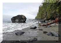
50. Bear Beach, about 9 km from China Beach. Going to the right (west).

Bear Beach in Juan De Fuca Provincial Park
51. Lots of stones, very little sand. 500 meters after the beach entrance.

Vancouver Island Bear Beach
52. A tent pad at Bear Beach. There is also a pit toilet present, and there was a lot of garbage chilling around the toilet area.

Bear Beach tent pad in Juan De Fuca Provincial Park
53-54. A neat yellow stone wall at Bear Beach in Juan De Fuca Provincial Park.


Juan De Fuca Marine Trail - Bear Beach
55. Juan De Fuca Trail hikers on Bear Beach. We saw a total of, maybe, 15 people during the entire round trip hike between Mystic Beach and Bear Beach, not counting people at Mystic Beach, which is quite popular. But this is September, and it would be substantially more crowded during the busy season.

Juan De Fuca Trail hikers
56. Bear Beach at 787 meters from the eastern beach entrance.

Bear Beach on Vancouver Island BC Canada
57. We then went to the opposite side of the beach from the entrance seen in photo #45. Here we are at the 260 meter mark from the beach entrance, looking back (west).

Juan De Fuca Provincial Park - Bear Beach
58. Approaching the eastern end of Bear Beach - 340 meters from the entrance.

Bear Beach
59. A bit closer.

Juan De Fuca Provincial Park
60. And here is a grotto at the eastern end of Bear Beach. Looking back (west) towards the beach entrance.

Bear Beach grotto
61. On the way back to China Beach, saw a flock of Brandt's Cormorants sunbathing on a rock.

Brandt's cormorants
We returned to China Beach the same way we came. The next stretch of Juan De Fuca Trail that we hiked was Sombrio Beach to Chin Beach (not to be confused with China Beach!), which is km 29 to 21 and back. We thus did not hike Juan De Fuca Trail between Bear Beach and Chin Beach (km 9 to 21), which, from what we have read, is the toughest part of the trail. Our Juan De Fuca Marine Trail Hike trip report Continues on Page 3.


|
 |
![]()
![]()
![]()
ihikebc.com Trip 301 - Juan De Fuca Trail Hike (near Sooke, BC)
Page 2 of 8