![]()
![]()
![]()

Trip 294 - August 30, 2023 (Wednesday)
Sidney Island Visit
Off Vancouver Island, BC
Page 3 of 3
Liked: Numerous fine shoreline views at the spit and the lagoon, many herons at the lagoon, shade in the forest, no bugs, interesting random mini-geysers at the spit (but see Of Note).
Of Note: Ferry service to Sidney Island (Sidney Spit) is seasonal, no fresh water on the island, noise from airplanes taking off from Victoria airport, from single engine aircraft, and from passing boats; random mini-geysers all over the place shooting up from the ground up to 1 meter high at the spit and occasionally hitting unsuspecting hikers, no shade at the spit. Lots of dirt and loose stones at the spit – hiking poles are recommended, and hiking boots are highly recommended (hiking boots are essential, if hiking through the mud by the lagoon).
Vancouver Island, Victoria & Gulf Islands Backroad Mapbook (9th edition) Town of Sidney Coordinates: Page 12 (Saturna Island) B6-B7.
Related Websites: Sidney Spit Ferry - Official Website, Sidney Spit Campground - Parks Canada.
Other Trips in Sidney BC Area: Town of Sidney Visit, Island View Beach Park visit.
Follow @ihikebc TweetSidney Island is a camping and hiking destination located just east of Vancouver Island, across from the town of Sidney, BC. A small passengers-only (48 persons capacity) ferry Sallas takes 15 minutes and $25 per an adult round trip (online booking required both ways) to get from Port Sidney Marina in Sidney to Sidney Island, AKA Sidney Spit. The Spit is actually one part of the island's public access, and the other part is a 800 meter-long trail in the woods to a rustic campground, run by Parks Canada (reservations required).
About 1/3 of Sidney Island is open to the public, and the other 2/3 is fenced-off private property. There are buoys near the public dock where you can moor your boat for a daily fee, or you can also use the public dock itself. Fees for both the dock and the buoys apply after 3 PM.
There is no fresh water on Sidney Island, so bring your own. If you miss the last ferry, which leaves mid-afternoon, or do not have a booking and the last ferry is full, you would be stuck, so plan accordingly.
Hiking on The Spit is fun, as there many fine shoreline views, and the other fun part is guessing if you would get hit by the next burst from a mini-geyser which shoot up from the ground for up to 1 meter. We could not figure out what caused this phenomenon - living creatures or some underground water pressure issues, but this sure was unexpected and perplexing. The Spit is about 1.8 km long and is North (left) of the dock. The path to the campground is South (right) of the dock, and the nearest pit toilet is in that direction, about 150 meters away.
For the campers with a lot of belongings (water!) there are wheelbarrows near the dock which can be used to take your stuff for 800 meters to the campground. The path then goes beyond the campground and goes through the woods for about 1.6 km, hits the fence which indicates the end of public property, and then goes along the fence for another 300 meters or so until you reach the other side of the island, where you can hike for a few more kilometers to the Northern tip of the lagoon across from the public dock.
The trail in the woods actually runs along the lagoon, but you can't see it from the path. So, the only way to see interesting lagoon views is to hike on the lagoon itself, but it is quite muddy, so hiking boots would be essential there. Once you reach the southern end of the lagoon by a small Eagle Islet, the hike around the lagoon towards the northwestern tip of Sidney Island continues on the grassy shoreline, or you can cross over and hike along the beach - check out the attached map for a better understanding of the layout of the place.
* All hiking distances are based on a GPS odometer and are approximate.
65. At 1.34 km from the gazebo, we have reached the end of the lagoon (the path in the forest ends nearby), turned right, and started hiking on the edge of the lagoon to the other edge of Sidney Island, while keeping Eagle Islet to our right.

Eagle Islet off Sidney Island BC
66. Now at the 1.87 km mark. Pleasant views all around.

Sidney Island
67. Another good view at 2.44 km.

Sidney Island BC
68. Now at 2.68 km. Coordinates: N 48⁰37.890’ W 123⁰20.169’. Elevation: 3 meters. We stopped here because of the need to catch the ferry. Another kilometer or so was remaining until the edge of Sidney Island. It would have been possible then to return via a beach to our left.

Sidney Island BC Canada
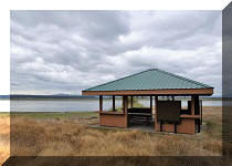
69-70. Looking right from where we stopped. Here is the gazebo across the lagoon. Plain and zoomed views.


Sidney Island gazebo
71. At first, going back the same way we came.

Hiking on Sidney Island BC
72. Approaching the point where we reached the end of the lagoon before starting to walk on the edge of it around Eagle Islet.

British Columbia hiking on Sidney Island
73. We then decided to return via the forest path. Had to briefly go through some bushes.

Sidney Island BC
74. And then we reached a fence which separates the public and private parts of Sidney Island.

Sidney Island British Columbia hiking
75. Park boundary.

Sidney Island park boundary
76. Briefly went to the right and reached the beach.

Sidney Island beach
77. Then, went back via a forest path. Looking back here at 200 meters from the beach. This is called Lagoon Trail.

Sidney Island BC
78-79. At 385 meters from the beach, reached a gate. The path then makes a left turn to parallel the lagoon.


Sidney Island British Columbia private property fence
80. Lagoon Trail at 1.52 km from the beach. Taking the path is longer distance-wise than hiking along the lagoon. Not nearly as muddy, of course, and few good views.

Lagoon Trail Sidney Island BC
81. At 1.66 km, we are out of the forest, and the campground is almost there. Turn left.

Sidney Island British Columbia Lagoon Trail

Sidney Island Trails Map
83. Hiking towards the lagoon again. At 1.69 km now.

Lagoon Trail on Sidney Island British Columbia Canada
84. A camping spot on the left side. But we turned right at this intersection.

Camping spot Sidney Island BC
85. At 2.72 km from the beach, we are approaching the dock.

Sidney Island British Columbia Canada
86. At 2.82 km, back at the info board.

Sidney Island BC
87. Heading towards Sidney Island dock. Here comes Sallas.

Sidney Island dock
88. A fine ferry it is.

Ferry Sallas at Sidney Island BC
89. On the way back.

Onboard Ferry Sallas
90. Farewell, Sidney Island and Sidney Spit.

Leaving Sidney Island
Sidney Island and Sidney Spit feature easy hiking and many fine natural views. Highly recommended.


|
 |
![]()
![]()
![]()
ihikebc.com Trip 294 - Sidney Island Visit (Off Vancouver Island, BC) Page 3 of 3